
Lexington Previous-Resident Sources
Lexington previous residents are documented in layers, not in one continuous list. A current Fayette parcel supplies the parcel number and legal description. Recorded deeds then identify owners, while directory street sections can name people printed at an address. Census schedules add household relationships at ten-year intervals. Maps show what stood on the lot. The best starting source depends on the period, and every result needs an edition, book, page, or record date.
| Source | Years It Covers | Where Held | What It Shows |
|---|---|---|---|
| Fayette deed index and images | Mid-1989 to present | Fayette deed portal | Grantor, grantee, instrument, legal description, book/page, and image |
| DAP deed and index books | Late 1700s through historical series | Fayette County Clerk | Early transfers, copied records, mortgages, surveys, and related books |
| Lexington directories | Examples from 1818 through 1992 | Kentucky Room, digital archives, KHS | Printed names, addresses, occupations, firms, and street entries |
| Federal census schedules | 1790 through 1950 public | NARA and library databases | Households, relationships, ages, occupations, and location context |
| Sanborn maps | 1886, 1896, 1901, 1907 | Library of Congress | Building footprint, use, street geometry, and block context |
For a recent chain, begin with the parcel and deed portal. For a twentieth-century household, move first to the closest street or Cross Directory. An older Lexington property may demand DAP books, surveys, maps, and a historical legal description before any modern street number makes sense. The sources overlap, but they do not prove the same thing.
Start With Lexington Address Records
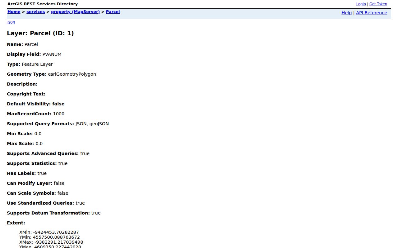
The LFUCG parcel layer exposes the fields needed to keep one lot distinct from the next: PVANUM, normalized address parts, acreage, class, condominium markers, cabinet or slide reference, and the date entered. PVANUM is the most useful bridge. Record it before moving to the Fayette PVA property search or the deed system.
Do not equate the owner field with the people living there. The situs address is the physical site, while a PVA mailing address may lead to an agent, estate, firm, or another home. A legal description can identify the land by lot, block, subdivision, or metes and bounds. Those distinctions keep a previous-residents search attached to the property even after names and numbers change.
The official parcel layer has a useful field view. The Lexington GIS source supplies the schema behind the image below and keeps previous residents tied to the correct tract.
Walk Lexington Deed Records Backward
A chain of title is the linked sequence of recorded property transfers. Start with the current parcel, then use the Fayette land-record portal. Its main indexed image range begins in mid-1989, and its changing “Instruments Verified Through” timestamp should be saved with the search date. Search both sides of a transaction because the buyer appears as grantee and the seller as grantor.
- Save the current PVANUM, owner field, situs address, and legal description from GIS and PVA.
- Find that owner's purchase deed. Record the grantor, book/page, instrument type, and recorded date.
- Search the seller as a grantee to locate the earlier purchase. Try spelling variants, estates, trusts, and company names.
- Repeat the link and compare each legal description. Stop if the land was split, combined, or conveyed under another description.
- Before mid-1989, move to prior indexes, DAP books, microfilm, or a specific copy request.
- Grantor and grantee
- The grantor gives an interest in land; the grantee receives it.
- Chain of title
- The linked series of recorded transfers for the same property.
- Legal description
- The recorded land identity, often a lot, block, plat, or boundary description that can outlast a street address.
The Clerk will provide copies, but staff do not conduct title searches. The land-record copy form accepts book/page or details such as parties, date, control number, property address, and document type. A noncertified copy is $0.50 per page. A certified copy is $5 for the first three pages and $0.50 per added page, with $1 postage and handling per mailed document.
Earlier Lexington Previous Residents
The main portal cutoff is not the end of Fayette land history. The Fayette Clerk Research Archive routes earlier work into series-specific images. Old deed Books A through Z reach from the late 1700s to September 1825. Later deed books cover selected runs into the twentieth century. The deed and mortgage index book spans 1794 through 1903.
Wills, partitions, orders, surveys, plats, easements, restrictions, and mortgages can explain a transfer that a deed row alone cannot. Wills in Books A through 16 cover 1793 through 1935. Partition Book 1 covers 1852 through 1903, while plats begin in 1880. These records may name heirs or describe a divided tract, but an heir named in a file was not necessarily a resident of the house.
The Fayette DAP instructions show how page-based books replace a modern full-text search. The official DAP guide is pictured below.
When online images are not enough, use the Clerk counter, phone, mail copy form, or written open-record request for an existing record. Kentucky Room, KDLA, KHS, and FamilySearch are the documented fallbacks for unscanned historical material.
Lexington's Burnt Records Detour
A fire destroyed the Fayette clerk's office on January 31, 1803. Surviving material was copied into eight Burnt Records volumes, and residents re-recorded deeds afterward. That history creates an important search rule: a broken early chain may reflect the record's form, not the absence of a transfer.
Check the Burnt Records books, re-recorded deeds, court orders, old surveys, and land-entry material before declaring a gap. Keep the copy status in any citation. A copied survivor, a later re-recording, and an original deed are different forms of evidence. This is one reason Lexington previous residents and early owners cannot be reconstructed by a single surname query.
Insider tip. Save the live verified-through date on every modern portal search, then record the exact historical series, book, and page used for each older link.
Resolve Lexington Address Records
An address printed in a directory may no longer resolve in a modern map. Lexington's E911 Address Change Search accepts direction, street name, and type, with options to search the old or new address. Results show New Address, Old Address, Resolution, and Resolution Date. That official link can explain a civic renumbering without implying that anyone moved.
Compare both versions with the PVANUM, deed legal description, directory year, and map sheet. If the street name is still unclear, the E911 Addressing Office at 101 East Vine Street, Suite 552 accepts in-person or phone questions at 859-258-3381 or 859-425-2254. Planning and Historic Preservation can supply added street or site context, while a city open-record request can seek an existing resolution or address log.
Note: The same lot may carry a modern situs address, an older printed number, and a deed description with no street number at all.
Map Lexington Residence History
The Library of Congress holds Lexington Sanborn fire-insurance maps for 1886, 1896, 1901, and 1907. The 1907 set has 97 sheets plus eight skeleton maps. These sheets can distinguish a dwelling, stable, business, school, church, alley, or vacant footprint. They can also reveal an old block shape that no longer matches the current parcel layer.
A Sanborn sheet does not identify every person inside a building. Pair it with a deed or plat for the land and a dated directory for printed occupants. For rural Fayette addresses outside the old urban grid, the 1912 and 1940 rural directories or 1971 farm directory may work better than a downtown street volume. PVA acreage and survey books can help confirm that rural fork when tracing previous residents.
Rebuild Lexington Previous Households
Owners are only one part of an address history. Lexington Cross Directories, street directories, phone books, and rural volumes may print occupants, subscribers, firms, or institutions by address. The 1906–07 Cross Directory includes alphabetical and street sections. Later points include the 1940 Cross Directory, 1942 Street Directory and Map, 1944 phone directory, and 1956 Street Directory. Full collection detail belongs on the Lexington city directory page.
Use a simple paired process: choose the directory edition nearest the target date, record the printed name and exact address, compare the alphabetical and street entries, then check the nearest public federal census year. Public population schedules currently run through 1950 under the 72-year release rule. Preserve the historical ward or enumeration district, since it may not match a modern ZIP or council district.
The Kentucky Room connects directories with the Local History Index, newspapers, maps, cemetery files, HeritageHub obituaries, and subject files. Only a fraction of its holdings is online. Ask staff about a name, street, house, institution, or year. KDLA, KHS, and the Lexington FamilySearch Center provide further in-person, phone, mail, email, catalog, and microfilm routes.
For pre-1911 life events, the Kentucky Historical Society and KDLA may hold records outside the modern state vital system. A probate file or obituary can explain why title passed, but the deed remains the source for the recorded transfer. Compare names, dates, and kinship terms instead of treating one index entry as a complete household history.
Lawful use. Research Lexington previous residents for house history, genealogy, and personal curiosity. Never use a historical trail to track, intimidate, or harass a living person.